Simulation of the effects of groundwater level on vegetation change by combining FEFLOW software
Ecological Modelling187(2005)
341–351
Simulation of the effects of groundwater level on vegetation change by combining FEFLOW software
Chengyi Zhao a,b,?,Yuchao Wang a,Xi Chen a,Baoguo Li c
a Xinjiang Institute of Ecology and Geography,Chinese Academy of Sciences,Urumqi830011,China
b Institute of Environment and Development,Chinese Academy of Agriculture,Beijing100081,China
c Department of Soil an
d Water Resources Sciences,China Agricultural University,Beijing100094,China
Received3November2003;received in revised form29September2004;accepted6October2004
Available online21February2005
Abstract
The numerical models for predicting two-dimensional groundwater?ow in the continental river watersheds were developed based on the water budget in the watershed,and by regarding the effects of groundwater depth on vegetation change as the source/sink factors.The vegetation changes patterns were classi?ed into several types according to climatic conditions and groundwater depths in the desert regions.The source/sink factors such as volumes of irrigation water and pumped groundwater were found to have the greatest effects on groundwater?ow.The variations of source/sink volumes were calculated in detail according to the irrigation systems for different crops.The other source/sink volumes associated with vegetation changes due to the vegetation type changes are of secondary importance,and they include mainly permeation and evapotranspiration of the limited precipitation and condensed water,and their volumes are distributed in the certain periods.The spatial data of the regional vegetation change were processed using GIS,and the effects of groundwater level on the vegetation change were simulated by combining the vegetation type changes with FEFLOW software.The results indicated that the groundwater level maintained a decreasing trend in the upper part of the marginal zone of fans and a continuously increasing trend in the alluvial–diluvial plains.This combined effect resulted in deterioration of vegetation on the upper part of the watersheds and a further soil salinization in the lower alluvial–diluvial plains.
?2005Elsevier B.V.All rights reserved.
Keywords:Vegetation change;Groundwater level;Coupling;Numerical simulation
1.Introduction
The coupled relationship between vegetation change and groundwater depth is important in the arid
?Corresponding author.Tel.:+869917885455;
fax:+869917885320.
E-mail address:zcy@https://www.360docs.net/doc/3f627023.html,(C.Zhao).zone,and thus has received a great attention in the past 20years(Fred,1981;Huete,1988;Harry and Wassen, 1997;Gullison and Bourque,2001;Krysanova et al., 1989;Poiani and Johnson,1993).Due to the shortage of surface water resources,the growth of plants has to depend on precipitation and groundwater in continen-tal river watershed.The change of vegetation cover-age is obviously affected by annual precipitation,and
0304-3800/$–see front matter?2005Elsevier B.V.All rights reserved. doi:10.1016/j.ecolmodel.2004.10.019
342 C.Zhao et al./Ecological Modelling187(2005)341–351
the vegetation types and the primary productive forces are determined by groundwater depth.Many studies have revealed that vegetation change,land deserti?ca-tion and soil salinization in the arid zone were closely related to the groundwater?ow(Chen and Qu,1992; Ci,1998;Salama et al.,1999).There are two main dif?-culties in simulating the coupling relationship between the effects of groundwater?ow on vegetation change at a regional scale,i.e.the processing of a large amount of regional spatial data and the complicated numeri-cal calculations.Fedra(1993)and Maidment(1993) researched the combination of GIS with the process models from the different aspects.Fayer et al.(1996) and Pavelic et al.(1997)simulated the groundwater recharge under the different ways of land use and pre-dicted the change of groundwater level.There were very few studies about simulating the regional ground-water?ow and the water consumption by taking into account the effects of groundwater?ow on vegetation change as the source/sink factors(Havard et al.,1995; Li et al.,2000).
The horizontal groundwater?ow in the continen-tal river watersheds in the arid zone includes mainly the run-off recharge in the perimontane zones and the lateral discharge in the deserts.The vertical groundwa-ter recharge includes mainly the percolation of irriga-tion water,precipitation and condensed water,and the vertical discharge is mainly the groundwater pumping, evapotranspiration of the plants and evaporation from soil surface in the areas where the groundwater depth is shallow.Many years of excessive groundwater ex-ploitation in the continental river watersheds resulted in the replacement of the natural discharge by arti?-cial exploitation,drawdown of groundwater levels in the upper reaches,drying-up of marshes and springs in the marginal zone of fans,secondary soil salinization in large areas in the lower reaches and degeneration of the natural vegetation in the https://www.360docs.net/doc/3f627023.html,ing a case study in the Sangong River Basin in China as an ex-ample,we illustrate the methodology for processing the spatial data of the regional vegetation change using GIS and simulating the effects of groundwater?ow on vegetation changes using FEFLOW software(Barlow and Brian,1996;Li et al.,2000).
The objectives of this study were:(a)to develop sim-ulation models for predicting the coupling relationship between ecological process and hydrological process in the continental river watersheds;(b)to analyze the effects of the two-dimensional groundwater?ow on re-gional vegetation change and(c)to incorporate several sink/source factors and the spatial pattern of vegetation changes in the complicated numerical calculations us-ing FEFLOW software.
2.Methods
2.1.Observation of the vegetation change
The Sangong River watershed is selected as the stud-ied area for observing the gradient changes of the plant community structure,vegetation coverage and primary productive forces in40plots of20m×20m located 500m south of the perimontane zone to the desert re-gions.The vegetation types change in the Sangong River watershed in three periods was studied by using 75aerial images of1:35,000in July1978,30colour infrared images of1:70,000in July1987and a TM image on August28,1998.The maps of eight vegeta-tion types,i.e.the desert vegetation,shrubbery,mead-ows,forests,marshes,arti?cial vegetation,annual plant communities and plant communities on the discarded farmlands were developed by the use of GIS.
2.2.Measurement of groundwater level
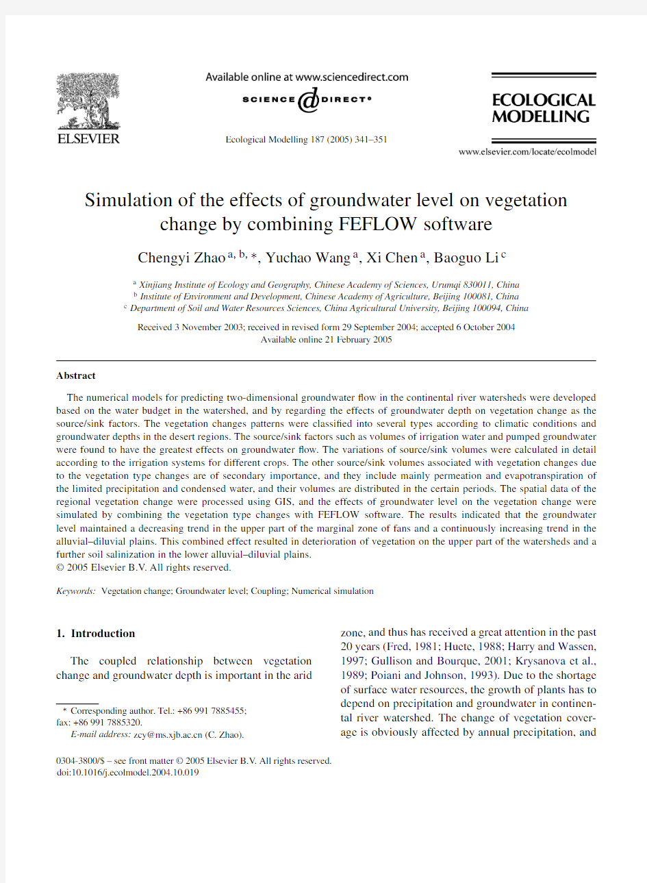
A total of258monitoring wells were distributed in the watershed to for perennially measure of the ground-water level,temperature and mineralization(Fig.1). Three measurements were taken per month in which measured data from15wells are selected to calibrate the simulated results.
2.3.Development of the mathematical models
According to the characteristics of the aquifer for-mation and of groundwater?ow in the Sangong River watershed,the hydrogeologic models were developed. Considering the non-obvious changes of the media in the phreatic aquifers in the alluvial plains,it can be assumed that the local media are homogeneous. The following assumptions can be made for the two-dimensional phreatic?ow on the plane of the horizontal impervious layers:(1)the change of head values at all the points of any section with z can be neglected and (2)the horizontal current velocity does not change with z.Based on these assumptions,the equations govern-
C.Zhao et al./Ecological Modelling187(2005)341–351
343
Fig.1.The study area and the monitoring wells distribution in the Sangong River Basin,China. ing the horizontal two-dimensional phreatic?ow in a
homogeneous anisotropic medium are as(Bear,1977;
Diersch and Thiele,1984;Diersch and Kolditz,1998)
??x
Kh
?H
?x
+
?
?y
Kh
?H
?y
+w(x,y,t)=μ
?H
?t
,
(x,y)∈?,t>0(1)
H(x,y,t)|t=t
=H0(x,y),(x,y)∈?(2)
H(x,y,t)|Γ
1
=h1(x,y,t),(x,y)∈Γ1,x>0(3)
h ?H
?ˉn
Γ2
=q(x,y,t),(x,y)∈Γ2,t>0(4)
where?is the domain of the simulated scope,Γ1 andΓ2the boundary of the?rst type and the second type,ˉn the direction of outer normal line of the second boundaryΓ1,H0(x,y)the initial conditions,i.e.the initial head distribution(m),h1(x,y,t)the?rst type boundary conditions(m),q(x,y,t)the second type boundary conditions with in?ow being negative and out?ow positive(m3/d),H the groundwater level (or head)(m),h the distance between the bottom elevation of the phreatic aquifer(z)and the phreatic free surface(m),K the permeation coef?cient of the aquifer(m/d),μthe water recharge and w(x,y,t) denote the source/sink factors of groundwater,i.e.the intensities of the vertical water pumping and of the percolation recharge per unit area(m/d).
The solution of Eq.(1)is found by?nite element method using the FEFLOW software(Diersch and Kolditz,1998).The interpolated values of the param-eters or variables can be achieved by many interpola-tion methods,such as Kringing and Akima.The?les in many formats including shp?le of ArcView and ASCII,etc.can be directly transferred and exported to analyze the results.According to the hydrogeologic features in the study area,it is determined that the study area,of7.642×108m2in generalized area,is from the southern boundary where the groundwater depth is50m to the northern boundary(Tangchao Road)of the desert zone and from the eastern boundary to the western boundary.The domain is divided into1476 triangular meshes and794total nodes.
2.4.Parameters
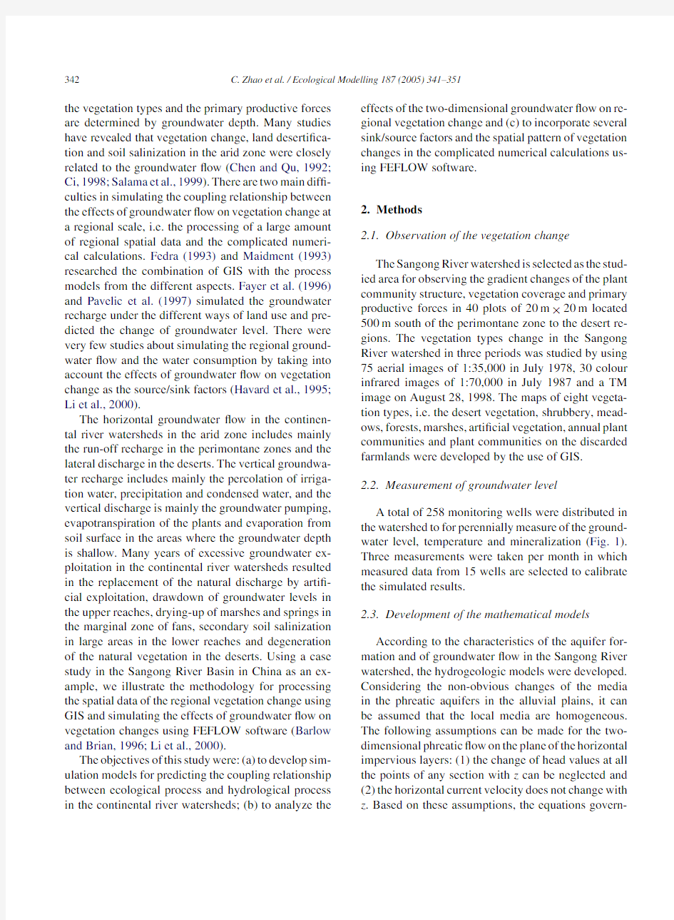
The parameters for calculating the groundwater?ow include the permeation coef?cient,rate of groundwa-ter recharge,bottom elevation of the water-barrier of phreatic aquifer and top elevation of the aquifer,etc. Based on the hydrogeologic maps and the section maps of the aquifer in the study area,the division maps of K andμare charted by using ArcView(Fig.2).
344 C.Zhao et al./Ecological Modelling 187(2005)
341–351
Fig.2.Distribution maps of the permeation coef?cient (K ,left)and of the degree of groundwater recharge (μ,right).
The ?les of the initial values are determined based on the data of groundwater pumping data,and are di-rectly transferred and tested by the FEFLOW,and the change of K and μcan be achieved with ArcView (Van Genuchten and Nielsen,1985).The elevation of the bottom barrier of the phreatic aquifer cannot be accu-rately determined due to the lack of data.Considering the aspects of the large area and the small horizontal head drop (1/1000–1/1500),it is determined that the depth of the phreatic aquifer is 100m and the eleva-tion of the bottom barrier of the phreatic aquifer in the simulation area is a ?xed value (230m),i.e.the value subtracted 100m from the elevation at the lowest place in the study area.The top elevations of the phreatic aquifer are the elevations of ground surface in the sim-ulation area.Thus,the groundwater depths can be cal-culated by the FEFLOW and the data can be exported as shape ?les in ArcView,and the map of groundwater depths can be charted using the ArcView.3.Principles and methods for determining the source/sink factors
3.1.Relationship between the different vegetation types and groundwater depth
The distribution of vegetation in the area corre-sponds to that of the surface water and groundwa-ter ?ows in the Sangong River watershed.When the
groundwater depth varies in a range of 1.0–2.0m,the meadow vegetation grows well,and the vegeta-tion coverage can be up to 40–70%.When it varies in a range of 3.0–4.5m,the meadow vegetation is basically withered,and the vegetation in the area is dominated by the desert xerophytes,such as Popu-lar diversifolia ,Elaeagnus angustifolia and Athagi pseudathagi and the vegetation coverage is reduced to 10–20%.When it varies in a range of 4.5–6.0m,some super-xerophytic short shrubs and semi-shrubs,such as Tamarix chinensis and Holoxylon ammoden-dron ,can basically grow except the mature P .diversi-folia ,and the vegetation coverage is generally 5–10%.To summarize,the salt tolerant meadow vegetation and forest–shrubbery–meadow vegetation in various species can grow well to form the stable natural oases under the conditions that the groundwater depth is shal-lower than 4.5m and the salt content is less than 3.0g/L.Therefore,it can be considered that the groundwater depth of 4.5m and the salt content of 3.0g/L are the critical threshold values for the ecology of the natural oases at the lower reaches of Sangong River watershed.If the groundwater depth is deeper than 4.5m and the salt content is higher than 3.0g/L,the natural oases will evolve towards deserts.
3.2.Determination of the source/sink factors In the models the source/sink factors represent the vertical groundwater recharge and discharge,and the
C.Zhao et al./Ecological Modelling187(2005)341–351345
effects of vegetation change are just the vertical in-crease or decrease of groundwater volume,so the source/sink factors in the models are the effects of veg-etation change on groundwater.Therefore,the correct processing of the source/sink factors such as the ef-fects of vegetation change on groundwater,and vice versa constitutes the key aspect of this study.Viewing from the present situation in the area,the vegetation patterns in the area include the desert vegetation,shrub-bery,meadows,forests,swamps,arti?cial vegetation, annual plant communities and plant communities on the discarded farmlands,etc.Regionally,the effects of the regional vegetation types patterns on groundwater depth can be listed in Table1.
Because the evapotranspiration and evaporation are strongly affected by the groundwater depth,the ef-fects of the same vegetation type on groundwater recharge are different under the different groundwater depths.In the Sangong River watershed,the ground-water recharge from precipitation and condensed water occurs only in the regions where the groundwater depth is shallower than4.5m,and the percolation volumes are the same with groundwater depths varying in the ranges of0–3and3–4.5m,respectively.The groundwater dis-charge from evapotranspiration and evaporation can be neglected when the groundwater depth is deeper than 4.5m.Similarly,the evapotranspiration and the evap-oration are the same in the regions where the ground-water depths vary in ranges of0–3and3–4.5m,
re-Fig.3.Map of the vegetation types in the simulation of groundwater ?ow:(1)vegetation types;(2)desert;(3)shrubbery;(4)meadow;(5) swamp;(6)arti?cial vegetation;(7)annual plant community and(8) plant community on discarded farmland.
spectively.Accordingly,the maps of vegetation types are superposed with the maps of groundwater depths in ArcView GIS,and some vegetation types in the re-gions where the groundwater depths and the effects of vegetation change on groundwater are the same are combined,and the vegetation types are reclassi?ed ac-cording to the groundwater depths.The new vegeta-tion types and their effects on groundwater are listed in Table1.The new vegetation types are shown as Fig.3.
Table1
Relationship between the vegetation types and the source/sink factors
S.No.Vegetation type Vegetation
coverage Groundwater
depth(m)
Source factor(+)Sink factor(?)
1Crops>0.80–2Irrigation,seepage of canal systems Evapotranspiration,pumping 2Economic forests>0.50–2Irrigation,seepage of canal systems Evapotranspiration,pumping 3Shrub forests>0.30–2Precipitation,seepage of condensed water Evapotranspiration
4Shrub forests>0.12–4.5Precipitation,seepage of condensed water Evapotranspiration
5Shrub forests<0.1>4.5No Evapotranspiration
6Forests in stretches>0.40–2Precipitation,seepage of condensed water Evapotranspiration
7Forests in stretches>0.22–4.5Precipitation,seepage of condensed water Evapotranspiration
8Forests in stretches<0.15>4.5No Evapotranspiration
9Natural grasslands>0.6<1Precipitation,seepage of condensed water Evapotranspiration
10Natural grasslands>0.31–2Precipitation,seepage of condensed water Evapotranspiration
11Natural grasslands>0.22–4.5Precipitation,seepage of condensed water Evapotranspiration
12Natural grasslands<0.2>4.5No No
13Unused lands<0.10–2Precipitation,seepage of condensed water Surface evaporation
14Unused lands02–4.5Precipitation,seepage of condensed water Surface evaporation
15Unused lands0>4.5No No
346 C.Zhao et al./Ecological Modelling187(2005)341–351
3.2.1.Processing of the source/sink factors of
arti?cial vegetation
The arti?cial vegetation means mainly crops,i.e. farmlands.It has the biggest effects on the groundwater in the watershed.It is the dominant source/sink factor of groundwater and is regarded as the surface factor in processing.The irrigation year in the Sangong River watershed starts from the winter irrigation using wa-ter from the reservoirs in mid October to next October. The most farmlands located at the lower reaches in the alluvial plains are irrigated by the reservoirs and the others are irrigated by stream waters and well wa-ter.Therefore,in processing the source/sink factors the maps of vegetation types are superposed with the ad-ministrative maps at township level.The irrigation sys-tems are determined based on?ve species of crops (i.e.wheat,seed melon,corn,cotton and others)and their growing areas.The volumes of well water and reservoir water for irrigating a certain crop in each sea-son of irrigation in the whole township are calculated according to the growing areas of all the crops and the irrigation systems.Then the pumped groundwa-ter volume is calculated based on the utilization co-ef?cients of the canal systems.The utilization coef-?cients of the canal systems are provided by Fukang City Bureau of water conservancy.A utilization coef-?cient(ηwh)of0.67of the canal systems for diverting well water and the percolation coef?cient(λ)of0.75 of the canal systems are used in the calculations(Van Genuchten and Nielsen,1985).It is estimated that the pumped water volume of each well is45m3/h and the pumping time is24h per day.Then the daily ground-water pumping intensity of a township can be calcu-lated based on the number of the wells distributed in the farmlands.The percolation coef?cient of irrigation water is determined by calculating the water consump-tion of crops and the irrigation water volume in the growth period of crops and compared with the esti-mated regional water budget.The total volume of the irrigation water including reservoir water and well wa-ter and of the percolation of the canal systems is the percolation volume of groundwater in the township units.
3.2.2.Processing of the percolation volumes of precipitation and condensed water
In the Sangong River watershed,the annual precipitation is180mm with quite low effective precipitation.Therefore,only the groundwater depth and the temporal distribution of precipitation must be considered in calculating the recharge of precipita-tion to groundwater.According to the groundwater budget of Sangong River watershed,the recharge from the permeation precipitation and condensed water to groundwater occurs only in regions where the groundwater depth is shallower than4.5m.As calculating the annual permeation precipitation,over 10mm of precipitation is considered as the average annual effective precipitation and the permeation coef-?cients of0.04–0.19were used based on the different groundwater depths.The total volume of the effective precipitation is distributed in3months,i.e.July,Au-gust and September.The annual volume of condensed water is10mm,which occurs mainly in autumn when the daily temperature change and the humidity are high.Therefore,the permeation of condensed water is distributed mainly in10days from October5to 15,and the daily permeation of condensed water is 1mm.
3.2.3.Processing of the groundwater discharge caused by evapotranspiration of the forests and grasslands
According to the climate in the Sangong River watershed,the main growing period of plants covers 8months from March to October,so the evapo-transpiration is signi?cant during this period but its seasonal difference is dramatic.According to the multi-years studies of the evapotranspiration of?ve plants in Sangong River watershed,the difference of average monthly evapotranspiration volumes varies signi?cantly for different months,and it occurs mainly in the period from March to October(Wang,1995; Famiglietti and Wood,1995).Accordingly,the groundwater losses caused by the evapotranspiration of forests and grasslands are proportionally distributed in8months from March to October.The average annual groundwater loss caused by evapotranspiration from the grasslands is156.9mm in the regions where the groundwater depth varies in a range of1–3m and 49.8mm in the regions where the groundwater depth varies in a range of3–4.5m.The annual groundwater loss from the farmland shelter-forests is480mm.The evapotranspiration volumes of the?ve plants are listed in Table2.
C.Zhao et al./Ecological Modelling187(2005)341–351347 Table2
The monthly transpiration volumes of the different species of plants(mm)
Time Plant species Monthly
average Distribution proportion(%)
Year Month Tamarix
chinensis Holoxylon
ammodendron
Popular
diversifolia
Pinus Sylvestris var.
mongolica
Ulmus
pumila
1994January1.20.10.31.00.60.640.11 February3.70.31.03.02.02.000.33
March17.51.54.914.09.59.481.58
April45.73.912.736.724.824.764.12
1993May71.620.35.589.234.444.207.35 June196.563.88.179.292.087.9214.63
July355.1124.758.8104.6181.3164.9027.43
August312.793.479.084.7168.7147.7024.57
September259.525.449.361.5103.499.8216.61
October29.82.58.323.916.116.122.68
November5.50.41.54.43.02.960.49
December1.10.10.30.90.60.600.10
Total1299.9336.4229.7503.1636.4601.10100.00
Table3
Calculation of the phreatic evaporation
Groundwater depth(m)<1m1–2m2–3m3–5m Total Area(km2)5.06382.828369.00049.360506.251 Evaporation(mm/d)2.7842.7842.7842.78411.135 Evaporation coef?cient0.1030.0550.0140.0100.182 Total evaporation(104m3/d)0.1451.2681.4380.1372.989
3.2.
4.Processing of the groundwater discharge caused by the soil evaporation
The soil evaporation means the evaporation in the area with no vegetation or low vegetation coverage, which is the phreatic evaporation under the steady evap-oration conditions.The highest evaporation in the San-gong River watershed occurs in June,followed by July, May,August and April.Speci?c evaporation coef?-cients and data are shown in Table3.
4.Results and discussion
The parameters used in the models are calibrated and the models are modi?ed by using the maps of the vegetation types pattern in1996and the measured data of groundwater depth during1983–1995.The calibra-tion makes the calculated results of the models match the measured data of groundwater depth as much as possible.The comparison between the simulated and the measured values of groundwater depth measured from14monitoring wells shows a similar groundwa-ter level trend with the hydrogeologic situation in the study area,which indicates that the generalized mod-els of the hydrogeologic conditions mentioned above are reasonable.The calibrated results of K andμare shown in Figs.3and4,respectively.The calibrated K andμvalues are close to the data of the test pits of the hydrologic department.The models are veri?ed by the measured data of groundwater depth in1996(the groundwater level was measured three times on6th, 16th and26th of every month).Fig.5shows the com-parison between the simulated values and the measured ones of groundwater depth from four monitoring wells (well No.6,12,4and7,located in the perimontane zone,marginal zone of fan,alluvial plain and marginal zone of desert,respectively)in1996,which shows that the change trend of the simulated values of groundwa-ter depth matches basically with that of the measured values,and the models can be used to simulate the ef-fects of regional vegetation change on the groundwater depth.
348 C.Zhao et al./Ecological Modelling187(2005)341–351
Fig.4.The isogram of the simulated groundwater level.
https://www.360docs.net/doc/3f627023.html,parison on the simulated values of groundwater level and the measured values of four monitoring wells.
C.Zhao et al./Ecological Modelling187(2005)341–351349
The spatial difference of the vegetation types pat-tern is considered in processing the source/sink factors in this paper.The source/sink factors of the temporal series are also analyzed in detail according to the ir-rigation systems and the change of rainfall.Thus,the models can be used to investigate the effects of the temporal and spatial changes of vegetation types on re-gional groundwater depth.The numerical simulations and the model veri?cation were based on the principle of water budget.For the whole watershed,the in?ow minus the water consumption is the discharge.Accord-ing to the measured hydrologic data of water resources during1961–1995,the annual run-off volume in the Sangong River watershed was9.51701×107m3,and the interannual change was not obvious,so neither was the interannual change of the lateral recharge volume. The boundary of the watershed is located in the desert zone at the lower reaches with very little impact from human activities,and the lateral discharge volume is negligibly low.Therefore,the processing of the water consumption factors,i.e.the vertical source/sink fac-tors in the watershed,is the key in the model veri?cation and the numerical simulations.The water consumption factors in the watershed include mainly the percola-tion of the canal systems,farmlands,rainfall and reser-voirs as well as the phreatic evaporation,water con-sumption and groundwater exploitation.The average values calculated by using the data during1985–1995 are compared with the results of the veri?cation model by using the groundwater level data collected in1996. Their budget values are close,and the budget rate is ?8.89%<–10%,which indicates that the budget rate is within the allowable range.Moreover,the effects of the different groundwater depths on the vegetation change can be predicted by using the simulated results. Furthermore,the scope of the vegetation degeneration can be predicted by combining the groundwater depth and its effects on the growth of plants.
Table4shows that the groundwater depth in the Sangong River watershed is mainly recharged by seep-age from canal systems and farmlands,which means that a considerable part of irrigation water perme-ates to groundwater under current irrigation systems. The groundwater consumption includes mainly the groundwater exploitation and the phreatic evapora-tion.For example,the volume of pumped groundwa-ter was1.8484×107m3in1982and was increased to 6.19784×10⁷m3in1995.The volume of the pumped groundwater is in an increasing trend.Meanwhile,it can be found that the volume of the lateral groundwater discharge is very small,which shows that the water ex-change between the groundwater and the environment is dominated by the vertical recharge and discharge,the recharge of soil water from irrigation and rainfall.
The water budget results in Table4show that the annual groundwater budget was?5.9099×10⁶m3 in the Sangong River watershed during1985–1995, and the groundwater in the watershed was exces-sively exploited especially in the upper part of the alluvial–diluvia fans.According to the long-term mea-sured data obtained during1982–1996,the dynamics of groundwater in the Sangong River watershed shows that the groundwater level is in a trend of continuous drawdown in the upper part of the alluvial–diluvial
Table4
Composition of groundwater in the Sangong River watershed(×104m3)
Item Factor Average(1985–1995)1996 Recharge volume Lateral recharge3390.233412.80
Percolation of canals1791.711887.24
Percolation of farmlands866.29891.00
Percolation of rainfall495.48495.48
Percolation of reservoirs536.71600.00
Total7080.437286.52 Consumption volume Lateral discharge405.00405.00
Phreatic evaporation1155.001090.94
Water consumption of plants1081.571081.57
Pumped groundwater volume5200.715300.00
Total7842.297877.51 Budget volume?761.86?590.99
350 C.Zhao et al./Ecological Modelling187(2005)341–351
fans and in an increasing trend in the alluvial–diluvia plains,which matches basically with the simulated results discussed earlier.The analysis shows that the main factor causing the drawdown of groundwater level is the excessive groundwater exploitation in a large scale.The continuous drawdown of groundwater level will cause the vegetation degeneration while the continuous increase of groundwater level will cause the salt accumulation in soils although the environmental problems,such as the deterioration of the geologic set-ting and decreasing water quality as well as the ground subsidence,have not occurred yet.For the sustainable utilization and development of water resources,it needs to be further studied to determine the reasonable exploitation volume of groundwater and the suitable range of groundwater level in the watershed.
5.Conclusions
The two-dimensional phreatic?ow models are se-lected in the study of the phreatic-slight-pressure-water system in the continental river watershed.The effects of vegetation change patterns on groundwater depth were considered as the source/sink factors.The vegetation changes patterns are classi?ed and merged into several types based on the arid climatic conditions.The irriga-tion water and pumped groundwater for irrigating the arti?cial vegetation have the biggest effects on ground-water,and temporal evolution for the volumes of the source/sink factors is calculated in detail according to the irrigation systems of the different crops in the dif-ferent regions.The source/sink factors of other vegeta-tion types are of secondary importance,which include mainly the permeation and evapotranspiration of the limited precipitation and condensed water.The spatial data of the regional vegetation change were processed by combining GIS and the FEFLOW model,which is used for calculating groundwater?ow.The effects of the vegetation change patterns on regional groundwa-ter depth can be simulated well by using the developed models in the desert oases.
The groundwater level is in a decreasing trend in the upper part of the alluvial–diluvial fans,but in an increasing trend in the alluvial–diluvial plains if the present status of vegetation surface water sources and utilization modes of water resources by excessively ex-ploiting groundwater is maintained.Therefore,it needs to be further studied to determine the rational exploita-tion volume of groundwater and the suitable range of groundwater level in the watershed,and to develop the water-soil exploitation modes based on the sustainable utilization of water-soil resources in the oases. Acknowledgments
This research was supported by Knowledge Innovation Project of CAS KZCX3-SW-326,KZCX3-SW-327and State Key Project G199943506.This work bene?ted from discussion with Martinus van Genuchten and Dr.Zhu Jianting in U.S.Salinity Laboratory.The author wishes to thank Dr.Zhi Wang of California State University,Fresno for making important suggestions on the original manuscript. References
Barlow,P.M.,Brian,J.Wagner,1996.Pumping strategies for man-agement of a shallow water table:the value of the simulation-optimization approach.Ground Water34(2),305–317. Bear,J.,1977.On the aquifer integrated balance equations.Adv.
Water Resour.(1),15–23.
Chen,L.H.,Qu,Y.G.,1992.Water and Land Resources and Rational Development in Hexi Region[M].Science Press,Beijing,pp.
1–78.
Ci,L.J.,1998.Occurrence mechanism and combating countermea-sures of China deserti?cation[J].Quat.Sci.(2),97–107. Diersch,H.-J.G.,Thiele,M.,1984.Finite element analysis of dispersion-affected saltwater upcoming below a pumping well.
Appl.Math.Model.8(5),305–312.
Diersch,H.-J.G.,Kolditz,O.,1998.Coupled groundwater?ow and transport:2.Thermohaline and3D convection systems.Adv.Wa-ter Resour.21(5),401–425.
Famiglietti,J.S.,Wood,E.F.,1995.Effects of spatial variability scale on areally averaged evapotranspiration.Water Resour.Res.31
(3),699–712.
Fayer,M.J.,Gee,G.W.,Rockhold,M.L.,et al.,1996.Estimating recharges rates for groundwater model using a GIS.J.Environ.
Qual.25,510–518.
Fedra,K.,1993.GIS and environmental modelling[A].In:Good-child,Michael F.,Parks,Bradley O.,Steyaert,Louis T.(Eds.), Environmental Modeling with GIS[C].Oxford University Press, Oxford,pp.35–50.
Fred,J.,1981.Models of water transport in the soil-plant system:a review.Water Resour.Res.17(5),1245–1260.
Harry,O.V.,Wassen,M.J.,1997.A comparison of six models pre-dicting vegetation response to hydrological habitat change.Ecol.
Model.101,347–361.
Havard,P.L.,et al.,1995.Link?ow:a water?ow computer model for water table management.Part1.Model development.Trans.
ASAE38(2),481–488.
C.Zhao et al./Ecological Modelling187(2005)341–351351
Huete,A.R.,1988.A soil-adjusted vegetation index.Remote Sens.
Environ.25,295–309.
Gullison,J.J.,Bourque,C.P.-A.,2001.Spatial prediction of tree and shrub succession in a small watershed in Northern Cape Breton Island,Nova Scotia,Canada.Ecol.Model.137,181–189. Krysanova,V.,Meiner,A.,Roosaare,J.,Vasilyev,A.,1989.Simula-tion modelling of the coastal waters pollution from agricultural watershed.Ecol.Model.49,7–29.
Li,Y.,Chen,D.L.,White,R.E.,2000.Coupling GIS with nitrogen leaching models[J].Pedosphere10(3),193–206. Maidment,D.R.,1993.GIS and hydrological modeling[A].In: Goodchild,Michael F.,Parks,Bradley O.,Louis Steyaert,T.
(Eds.),Environmental Modeling with GIS[C].Oxford Univer-sity Press,Oxford,pp.147–167.Pavelic,P.,Narayan,K.A.,Dillon,P.J.,1997.Groundwater?ow mod-eling to assist dry land salinity management of a coastal plain of southern Australia.Aust.J.Soil Res.35,669–686.
Poiani,K.A.,Johnson,W.C.,1993.A spatial simulation model of hydrology and vegetation dynamics in semi-permanent prairie wetlands.Ecol.Appl.3(2),279–293.
Salama,R.,Hatton,T.,Dawes,W.,1999.Predicting land use impacts on regional scale groundwater recharge and discharge.J.Environ.
Qual.28,446–460.
Van Genuchten,Nielsen,D.R.,1985.On describing and predicting the hydraulic properties of unsaturated soils.Ann.Geophysicae 3(5),615–628.
Wang,J.Q.,1995.Measurement of tree transpiration.Xinjiang Forest Technol.(1),10–13.