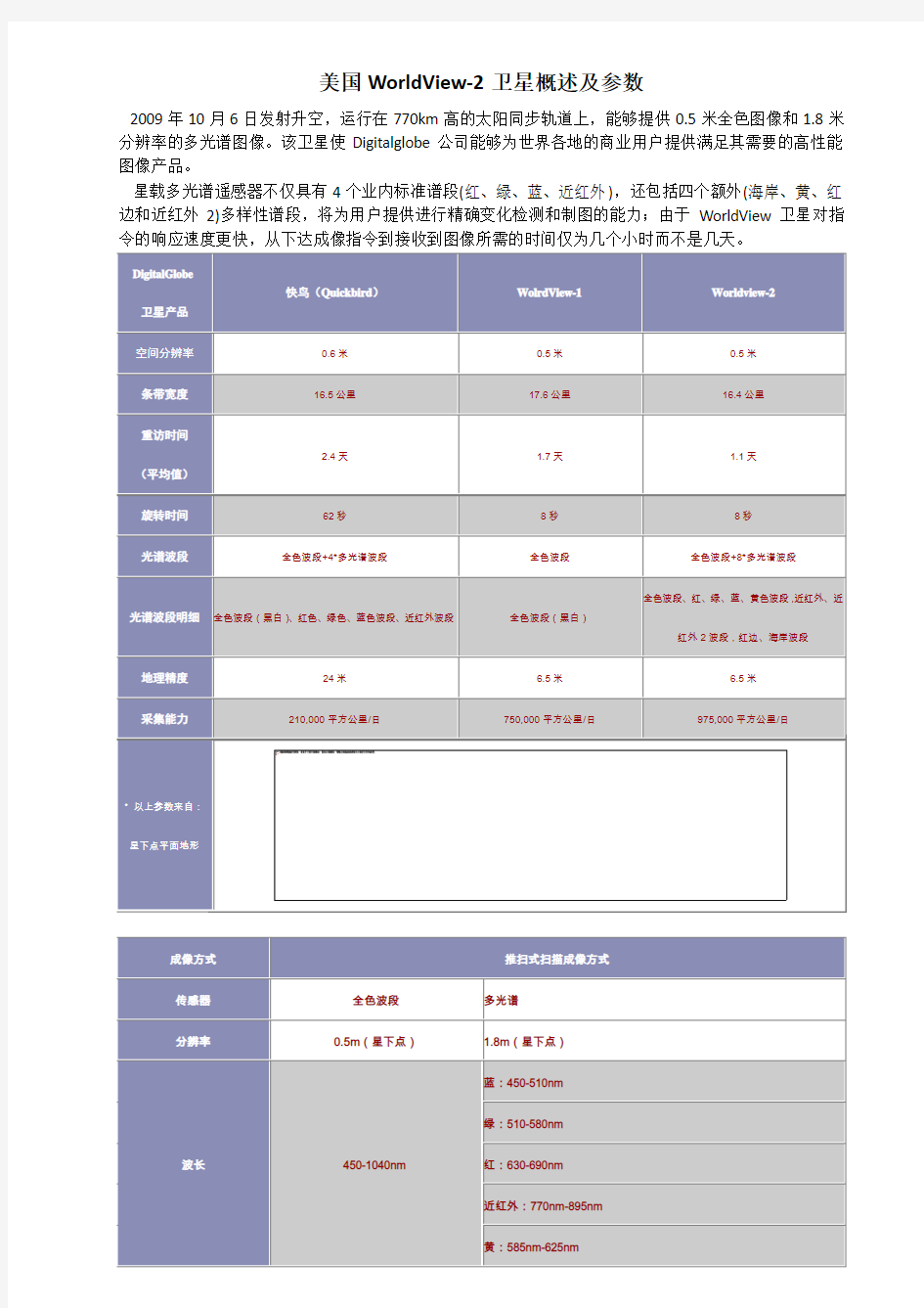
美国WorldView 2卫星概述及参数

American History 英美概况美国历史
American History ?I. America in the colonial era ?II. The War of Independence ?III. The Civil War ?IV. America during the two World Wars I. America in the colonial era ?Who were the very first Americans? ?Who was the first one discovering the new continent? ?After whom was the new continent named? I. America in the colonial era ?1.The very first Americans were Indians. ●They created their civilization, known as Maya civilization, dominating Mexico and Central America from 4th to the 10th centuries. ●They were the descendants of the Mongoloid (蒙古人种的) people in Asia. ●About 20,000 years ago, they traveled to the North American continent across the Bering Strait (白令海峡). ?2. Christopher Columbus is believed to have discovered America. ●In 1492, Christopher Columbus discovered America. However, he believed he had reached India and called the natives Indians. ?In 1500, Amerigo Vespucci, an Italian navigator, also under the Spanish flag, drew the conclusion that what he found was a new continent. 3. The establishment of colonies ?Since the America was found, the Spanish established many colonies: Florida, Los Angeles, and San Francisco. ?In 1588, the Spanish Armada was defeated by the English navy,which put England in a better position to provide support for its New World colonies. 3. The establishment of colonies ?Between 1607 and 1733 the British established 13 colonies along the east coast of North America. ?These 13 colonies were established in different patterns: ●crown colonies ( 直辖殖民地), ●proprietary colonies ( 业主殖民地), ●charter colonies ( 特许公司殖民地), ●self-governing or compact colonies ( 自治殖民地或契约殖民地). ?1) The first successful English colony in North America was founded at Jamestown, Virginia , in 1607. ?2) In 1620, a group of Pilgrims sailed to the New World in a ship called Mayflower. They arrived at Plymouth, and built the New Plymouth colony in New England. These Pilgrims drew up the epoch-making Mayflower Compact (五月花契约), which was signed by all adult males on the ship. 3. The establishment of colonies ?3) From 1630 to 1643, some 200 ships transported over 20,000 Englishmen to the Massachusetts Bay colony. ?Plymouth remained a separate colony until 1691 when it was combined with Massachusetts Bay colony. Puritans ?People who criticized or wished to "purify" the Church of England. ?"Puritan" refers to two distinct groups: ?"separating" Puritans, radical Protestants, such as the Plymouth colonists, the pilgrims, who believed that the Church of England was corrupt and that true Christians must separate themselves from it; and ?“non-separating” Puritans, such as the colonists who settled the Massachusetts Bay Colony, who believed in
英美概况美国部分整理
America The Founding of Colonies殖民地的建立 First Inhabitants:American Indians Discovery of the New World: 1492 Christopher Columbus →the discoverer of America (Italian)Spanish Queen’ s support 1501-2 Amerigo Vespucci →the new land was name after him as America. reached the mouth of Amazon River America—the New World Europe—the Old World 13 colonies: New England Colonies: Mid Atlantic Colonies: Southern Colonies: Massachusetts →(2nd colony,1620)New York Maryland New Hampshire Pennsylvania Virginia →(1st colony,1607)Rhode Island Delaware North Carolina Connecticut South Carolina Georgia →(the last colony,1733)New England Region(6个): Massachusetts, Rhode Island, Connecticut, New Hampshire, Maine and Vermont 建立原因: Virginia, 1607 Virginia Company For foreign expansion as a way of easing religious dispute and economic distress in England 105 men (no women) Jamestown in honor of the king Massachusetts In 1620 102 Puritans (“Pilgrim Fathers”), in Mayflower, from Plymouth in England to America First in Plymouth (today’s Massachusetts); and then Boston Seek religious freedom Mayflower Compact <五月花号公约>:self-government Hardships when arrived the help of the Indians Thanksgiving Day to thank the Indians and the God for protection The next three colonies Rhode Island, Connecticut, New Hampshire Reasons: 1. religious disputes and struggles in Massachusetts intensified 2. more immigrants
美国-国家概况、风土人情
美国概况及风土人情 首先要想做好美国项目就要了解目的国家的历史,政治经济,文化背景,风土人情等。相对于中国具有上下5000年的古老历史文明,美国作为一个新兴的资本主义国家,拥有的历史并不算漫长。 美国历史 最早可以追溯到15世纪左右,那时的美国本土居住着大量的土著印第安人。并没有被近现代文明社会所发现,直至意大利人航海家哥伦布发现了北美洲大陆,在1492-1502,十年间,哥伦布在西班牙的资助下四次横渡大西洋,达到美洲大陆。可以说;是哥伦布把欧洲的现代文明带到了美洲大陆。自从哥伦布发现了现代文明后, 在1776年7月 4日,反对英国殖民者的军队在费城召开了第二次大陆会议,组成“大陆军”,由乔治。华盛顿任总司令,并通过了《独立宣言》,那么这一天就被成为美国历史上最著名的“独立日” 1783年9月3日,独立战争结束。美国成为美洲首个独立国家。” 1787年制定联邦宪法。 1788年乔治。华盛顿当选为第一任总统。
美国地图: 美国位于北美洲中部:东濒大西洋,西滨太平洋,北靠加拿大,南接墨西哥及墨西哥湾。除美国简称USA,US,是由50个州和华盛顿哥伦比亚特区组成的联邦共和立宪制国家。 面积与人口: 美国国土面积世界第四;第一俄罗斯,第二加拿大,第三中国,大约为962.9万平方公里陆地面积915万平方公里,内陆水域面积为20万平方公里,五大湖中美国主权部分约为17万平方公里。河口,港湾,内海等沿海水域面积约10万平方公里。 美国人口约3.1 亿人,数量为世界第三。第一是中国,第二是印度,以白人为主,但有大量的移民人口。 主要城市 华盛顿:纽约所担任的职能仅限于经济范围内,而美国的首都华盛顿是纯粹的政治中心。区别于中国的首都北京所具有的政治经济文化中心的职能所不同的,美国的很多城市都具有单一的职能性。举例来讲美国的首都华盛顿只是政治中心,全程华盛顿D.C。最著名的景点就是美国的国会大厦,白宫,以及白宫正对面的华盛顿纪念碑。 美国的纽约不仅具有金融中心这一特点,同时他也是灾难的中心。他的出名也许会因为股市的反弹一夜暴富,也许会因为911的撞击事件而失去生命。 纽约市The city of New York 金融,文化,艺术的中心 纽约市是美国最大及人口最多的城市,也是全世界最大的都会区之一。 纽约在商业和金融的方面发挥巨大的影响力。该市有曼哈顿区,皇后区,布鲁克林区,布朗克斯区,斯塔腾岛五个区。 纽约市是美国第一大港,同时也是世界第四大都会区,仅次于东京,首尔,墨西哥城。 历史事件:2001年9月11日,911事件,恐怖分子劫持四架飞机,两架分别撞向两座世界贸易中心,一架撞向五角大楼,造成3000人死亡。 洛杉矶City of Los Angeles 洛杉矶是美国第二大城市,仅次于纽约,拥有巨大影响力的国际化大都市。 洛杉矶人口是加州最多的,超过400万人口,仅次于纽约。 大学有;加州理工学院,加州大学洛杉矶分校,南加州大学,洛杉矶加利福尼亚州立大学 旧金山 San Francisco
四颗worldview卫星影像介绍
北京揽宇方圆信息技术有限公司 WorldView WorldView卫星是Digitalglobe公司的商业成像卫星系统。它由两颗(WorldView-I和WorldView-II)卫星组成。 WorldView-1 WorldView-1卫星为美国DigitalGlobe公司的高分辨率商用卫星,于2007年9月18日成功发射,可提供0.5m分辨率卫星影像。灵活的镜头使其能够快速定位目标和高效的进行立体采集。 WorldView-1卫星基本参数 发射日期2007年9月18日 运行时间超过7年(燃料超过10年以上) 轨道形式太阳同步卫星 轨道高度496公里 飞行周期94.6分钟 影像幅宽17.6公里 重访周期 1.7天(优于1m分辨率) 4.6天(0.5-0.59m分辨率) 空间分辨率全色影像: 0.5m(星下点拍摄) 辐射分辨率11bit 全色波谱范围450-900nm 定位精度设计6.5m,实测4.0-5.5m (无控制点状态) 采集能力75万平方公里 WorldView-2 WorldView-2卫星于2009年秋成功发射,是全球第一颗具有8个多光谱波段的商业高分卫星,运行在770km高的太阳同步轨道上,能够提供0.5米全色影像和1.8米分辨率的多光谱影像 WorldView-2卫星基本参数 发射日期2009年10月8日 运行时间10-12年 轨道形式太阳同步卫星 轨道高度770公里 飞行周期100分钟 影像幅宽16.4公里 重访周期 1.1天(优于1m分辨率) 3.7天(以0.52m分辨率成像时) 空间分辨率全色影像: 0.46m(星下点拍摄) 多光谱影像: 1.85m(星下点拍摄) 辐射分辨率11bit 全色波谱范围全色 多光谱波谱范围蓝:450-510nm
英美概况 美国篇
一、概况 1.50 States Its forty-eight contiguous states and Washington, D.C., the capital district, lie between the Pacific and Atlantic Oceans, bordered by Canada to the north and Mexico to the south. The state of Alaska is in the northwest of the continent, with Canada to the east and Russia to the west across the Bering Strait. The state of Hawaii is an archipelago in the mid-Pacific. The country also possesses several territories in the Caribbean and Pacific. 2.Races and Population 在东部时间2006年10月17日早晨7点46分,美国人口总数突破三亿大关,这是美国人口史上具有里程碑意义的一刻。3.06188亿(2009年,世界国家和地区第3名,次于中国、印度) 3.The Composition of American Population 1)The Majority:the descendants of immigrants from European countries, such as France, Germany, Italy, Ireland, and Spain;“Pilgrim Fathers”;Potato famine 2)The Minorities:The African Americans: black slaves from Africa;Indians: the number of native Americans has been falling, no more than a million;The Hispanics: immigrants or descendents of immigrants from Latin America, such as Cuba and Mexico (Mexicans are the most numerous among them);Asian-Americans, from China, Japan and Korea;More than a million Chinese-Americans, most of whom live in Hawaii, on the West Coast and in some big cities;5 million Jews in America, many of whom went there during the Second World War and achieved great success in America. 3)“The Melting Pot”:It means immigrants from different nations all over the world have mixed to make up the American nation.“old immigrants”: came to America before 1860;“new immigrants”, after 1860.The Immigration Quota Law was passed by the American government in 1924. 二、Early History 1.Columbus:1492 Christopher Columbus arrived at Salvador Island, thus discovered the “New World”.(Amerigo V espucci: named “America”) 2.The first English permanent settlement:1607 The first group of English colonies came to America and built their settlement of Charleston which later was expanded into the first English colony known as Virginia. 3.Pilgrim Fathers:1620 Some English immigrants (Puritans) sailed into Plymouth on a ship called the “Mayflower”.102 Puritans, 60 days.Mayflower Compact, “one man one vote”, “one-man rule” 4.The values of Puritans:hard work; commercial success; the importance of education 5.Thanksgiving:1621 Thanksgiving Day was first celebrated by the pilgrims of the Plymouth Colony. 三、American Revolutionary
worldview3辐射定标的使用方法
Radiometric Use of WorldView-3 Imagery Technical Note Date: 2016-02-22 Prepared by: Michele Kuester This technical note discusses the radiometric use of WorldView-3 imagery. The first two sections briefly describe the WorldView-3 instrument and general radiometric performance including the WorldView-3 relative spectral radiance response and relative radiometric correction of WorldView-3 products. Section 3 covers conversion to top-of-atmosphere spectral radiance and conversion to top-of-atmosphere spectral reflectance. WorldView-3 imagery MUST be converted to spectral radiance at a minimum before radiometric/spectral analysis or comparison with imagery from other sensors in a radiometric/spectral manner. The information contained in this technical note applies to the raw WorldView-3 sensor performance and linearly scaled top-of-atmosphere spectral radiance products. Caution is advised when applying the equations provided here to pan-sharpened products, dynamic range adjusted (DRA) products, or WorldView-3 mosaics with radiometric balancing because the generation of these products may apply non-linear transformations to the pixel DN values. 1 WorldView-3 Instrument The WorldView-3 high-resolution commercial imaging satellite was launched on August 13, 2014, from Vandenberg Air Force Base. The satellite is in a nearly circular, sun-synchronous orbit with a period of 97 minutes, an altitude of approximately 617 km, and with a descending nodal crossing time of approximately 10:30 a.m. The revisit is 4.5 days at a greater than 20-deg off nadir angle. WorldView-3 acquires 11-bit data in 9 spectral bands covering panchromatic, coastal, blue, green, yellow, red, red edge, NIR1, and NIR2. An additional shortwave infrared (SWIR) sensor acquires 14-bit data in eight bands covering the 1100 to 2500 nm spectral region. See Table 1 for details. At nadir, the collected nominal ground sample distance is 0.31 m (panchromatic), 1.24 m (multispectral) and 3.7 m (SWIR). Commercially available products are resampled to 0.3 m (panchromatic), 1.2 m (multispectral) and 7.5 m (SWIR). The nominal swath width is 13.1 km (slightly less for the SWIR sensor). The WorldView-3 instrument is a pushbroom imager, which constructs an image one row at a time as the focused image of the Earth through the telescope moves across the linear detector arrays, which are located on the focal plane. 1.1 WorldView-3 Relative Radiance Response The spectral radiance response is defined as the ratio of the number of photo-electrons measured by the instrument system, to the spectral radiance [W-m-2-sr-1- m-1] at a particular wavelength present at the entrance to the telescope aperture. It includes not only raw detector quantum efficiency, but also transmission losses due to the telescope optics and filters. The spectral radiance response for each band is normalized by dividing by the maximum response value for that band to arrive at a relative spectral radiance response. The curves for theWorldView-3 visible and near infrared multispectral bands are shown in Figure 1. The curves for the WorldView-3 SWIR bands are shown in Figure 2. The corresponding data are provided in Attachement A.
英美概况资料
1. The longest river in Britain is ____. A. Severn B. Tees C. Thames D. Clyde 2. The British Isles is made up of ____. A. Three large islands and hundreds of small ones B. Two large islands and hundreds of small ones C. Three large islands and dozens of small ones D. Two large islands and dozens of small ones 3. There are three political divisions ____ on the island of Great Britain. A. England, Scotland, and Ireland B. England, Scotland, and Wales C. England, Scotland, and Northern Ireland D. Northern Ireland, Wales and Scotland 4. The Tower of London, located in the centre of London, was built by ____. A. King Harold B. William the Conqueror C. Robin Hood D. Oliver Cromwell 5. St. Paul’s Cathedral is in ____. A. Liverpool B. London C. Glasgow D. Birmingham 6. The largest lake in Britain is ___. A. Ullswater B. Loch Lomond C. Windermere D. The Lough Neagh 7. The Romans led by Julius Caesar launched their first invasion on Britain in ____. A. 200 B. C. B. 55 A. D. C. 55 B.C. D. 410 A.D. 8. The capital of Northern Ireland is ____. A. Belfast B. Birmingham C. Edinburgh D. Cardiff 9. Between 1337 and 1453 the ____ took place in Britain. A. Wars of Roses B. Black Death C. Hundred Year’s War D. Peasants Uprising 10. The first Civil War in Britain lasted from ____ to ____. A. 1600—1604 B. 1640—1644 C. 1642—1646 D. 1646—1650 11. James Watt created a ____ in 1769. A. Spinning Mule B. Steam Engine C. Power Loom D. Spinning Jenny 12. In English individualistic culture, one should not bother Englishmen without a good reason and making appointment beforehand seems to be important. It is best reflected by an English proverb____. A. as welcome as a storm B. an Englishman’s house is his castle C. do not wear out your welcome D. outstay one’s welcome 13. ____ is the first weekday after Christmas, a legal holiday in English, Wales, Northern Ireland, New Zealand, Australia and South Africa. A. Thanksgiving Day B. Anzac Day C. St. Valentine’s Day D. Boxing Day 14. The Bible was originally written in ____. C A. Latin B. English C. Hebrew D. Arabic 15. Which of the following king was executed in the civil war? A. James I B. Charles I C. James II D. Charles II 16. From 1649 to 1658 English was called a Commonwealth. It was ruled first by Oliver Cromwell as ____ .
英美概况地理位置
1.Alaska and Hawaii are the two newest states in American.Alaska northwestern Canada,and Hawaii lies in the central Pacific. 阿拉斯加和夏威夷是最近加入美国的两个新州。阿拉斯加在加拿大的西北部,夏威夷位邻中太平洋。(本细节还有考"一句话简答"的可能) 2.The U.S has a land area of 9.3 million square kilometres.It is the fourth largest country in the world in size after Russia,Canada and China. 就面积而言,美国是世界第四大国,就人口而言,美国是世界是第三大国。 3.Of all states of American,Alaska is the lagest in area and Rhode Island the smallest.But on the mainland Texas is the largest sate of the country. 所有州中,阿拉斯加是面积最大的州,罗得岛最小,在美国大陆,最大的州是得克萨斯州。 4.The Rockies,the backbone of the North American Continent,is also known as the Continental Divide. 落基山脉是北美大陆的脊梁,也被成为大陆分水岭。 5.The two main mountain ranges in American are the Appalachian mountains and the Rocky mountains. The Appalachians run slightly from the northeast to southwest and the Rocky mountains run slightly from the northwest to southeast. 阿巴拉契亚山脉和落基山脉是美国的两座大山脉。(本细节有考"一句话简答题"的可能) 6.The Mississippi River is the largest river in American,over 6000 kilometers.The Mississippi has been called "father of waters"or "old man river" 密西西比河是美国最长河流,有被称作"众水之父"或"老人河"。 7.The Ohio river has been called the American Ruhr,As in Germany, the area along the river is rich in valuable deposits of high-grade coking coal and is well known for its steel industry.The river provides cheap water transportation for raw materials. 俄亥俄河被称作美国的鲁尔河,就像德国一样,沿河有丰富的高品千周的焦煤,并且因其钢铁而著名。另外,该河还为原材料提供了廉价的水路运输。 8.On the Pacific side there are two great rivers:the Colorado in the south and the Columbia ,which rises in Canada. 太平洋沿岸有两大河:科罗拉多河及哥伦比亚河。 9。The Rio Grande River forms a natural boundary between Mexico and the United States. 格兰德河是美国和墨西哥之间的开然界河(本细节考选择和简答可能性大)10.the most important lakes in the United States are the Great Lakes. They are Lake Superior,which is the largest fresh water lake in the world, Lake Michigan ,the only entirely in the U.S.,Lake Huron,Lake Eire and Lake Ontario.They are located between Canada and the United States except Lake Michigan. 美国最重要的湖泊是五大湖:苏必利尔湖,密歇根湖,休伦湖,伊利湖和安大略湖,其中,苏必利尔湖为世界最大淡水湖,密歇根湖完全是美国境地内。
美国概况 Unit 1
英美文化与概况 British and American Studies ( American Part ) Unit One 大学英语第一教研室余非 2011年2月
Unit 1 The United States and American People Contents 1.Geographical Position and Area of Land 2.Rivers and Lakes 3.American People 1. Geographical Position and Area of Land The full name of the United States of America (USA) is sometimes abbreviated to the United States (US) or simply to America. With the fourth largest territory in the world , the United States is the world’s largest economy and its development involved many contributing factors. Rich land resources with varied geographical conditions is an important factor that contributes to America’s development . The territory of the United States includes Mainland America, anumber of islands and some overseas territories. The United States consists of 50 states with a total land area of about 9.4 million square kilometers . Two of the 50 states are separated from the continental United States. They are Alaska and Hawaii. Mainland America extends about 5,000 kilometers from east to west, and about 2,500 kilometers f rom south to north. Its coastline is about 20,000 kilometers. Neighbors of the United States: North:Canada; South:Mexico; West:Pacific Oceans; East: Atlantic Ocean. Mainland America can be generally divided into three basic geographical areas or surface region : A)The Atlantic Seacoast and the Appalachian Mountains B)The Mississippi River Valley C)The Rockies and the Pacific Ocean ●Atlantic Seacoast and Appalachian Mountains The Atlantic Seacoast is a strip of fairly level country between the Atlantic and the Appalachians. It is the country of the first European immigrants and the 13 original states. ●The Mississippi River Valley The Mississippi River Valley, also known as the Central Plain , consists of the large area between the Appalachian on the east and the Rocky Mountains on the West. The sediment of the rivers makes the soil of the region very rich, thus, the central Plain enjoys the name of “Barn of America”. ●The Rockies and the Pacific Ocean The Rockies On the west side of the Great Plain are Rocky Mountains, also known as “the backbone of the continent”. It stretches from Mexico into Wyoming and interrupted by Wyoming Basin. Rocky Mountains are well-known for their striking and varied scenery : Yellow Stone National Park, Grand Canyon, Las Vegas, Death V alley。